


TOP > Topics > 2005 > Which direction is "north" on Itokawa?
![]()
Which direction is "north" on Itokawa?
There is no up and down in space, but we can define "north" and "south" on a rotating celestial body. The poles are located at the intersection of the body's spin axis and its surface. But, how can we distinguish north from south?
When we project the Earth's spin axis into space, we will see a star at one end in the constellation Ursa Minor. This is Polaris that approximately defines the "north" of the equatorial celestial coordinates. If we look down at the Solar system from the "north" side, all planets are revolving around the Sun in the counterclockwise direction with similar orbital inclinations. While the Earth is also rotating in the counterclockwise direction with a 23.5 degrees tilt to the orbital plane, Venus is rotating in the clockwise direction around an axis that is almost perpendicular to its orbital plane (Figure 1). The north of a planet lies on the "north" side of the invariable plane.
Figure 1 |
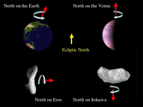
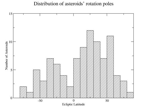
But this definition causes trouble when applied to asteroids and comets. Figure 2 shows a distribution of asteroids' spin axes in ecliptic coordinates. One may immediately notice that some asteroids have their rotation axes almost parallel to the ecliptic plane. A famous example is EROS, the target of Shoemaker/NEAR mission of NASA. If such asteroids have a large precession or a polar motion, the definition of "north" for planets would break down. So the International Astronomical Union established another rule to define "north" for asteroids and comets in 2003. In the right-hand rule, the north pole is the pole around which the object rotates counterclockwise.
Figure 2 |
Let's check the images of Itokawa or animation of the rotation. Since the "top" of these images and animation corresponds to the ecliptic north and Itokawa is an asteroid, it is rotating in the clockwise direction as seen from the ecliptic north direction and consequently "north" on Itokawa is "down" in figure 1.
The Hayabusa shape-modeling team is now constructing a map of Itokawa, on which they designate sampling points, MINERVA's hopping path, and the location of a target marker carrying a plate inscribed with eight hundred and eighty thousand people's name. When you see the first extra-terrestrial map made in JAPAN, please pay attention to the "north" direction.

October 31, 2005