


TOP > Topics > 2005 > Altitude Estimation using Navigation Camera
![]()
Altitude Estimation using Navigation Camera
Hayabusa spacecraft detects the line of sight vector toward ITOKAWA using an Optical Navigation Camera (ONC) and measures the range to ITOKAWA with a laser altimeter (LIDAR), which can realize three-dimensional relative navigation. Since the beam width of LIDAR is about 0.05deg, however, the range measurement is possible only when the spacecraft points to ITOKAWA. Therefore, we are developing the altitude estimation method using only a navigation camera.
The size of ITOKAWA on an image taken by ONC depends on the range to ITOKAWA. Since ONC has a function to calculate the direction and size of bright objects on an image, those numerical data are enough to estimate the relative position, not having the original image itself. The shape of ITOKAWA is not spherical and the size of ITOKAWA image varies according to its rotational motion, even though the distance to ITOKAWA does not change. Therefore, to estimate the altitude from the size (the number of pixels) of the image, the compensation of rotating phase is required, based on the observation data.
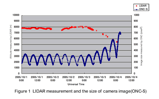
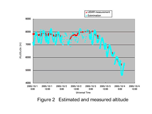
Figure 1 shows the altitude measured with LIDAR and the size of ITOKAWA on the ONC image from October 1st to 4th. The size increases when the altitude decreases and varies with the rotational motion of ITOKAWA whose period is about 12 hours. We assumed that the variation of size was sinusoidal and tried to compensate the effect of the rotation. Figure 2 shows the estimated and measured altitude. Accuracy of the estimation is about 1km. To improve the accuracy, we try to compensate with 3D shape model of ITOKAWA which is now under construction.
|
|

October 21, 2005